Is Nacimiento-Fergusson Road open?
The only road across the Santa Lucia Range between Monterey and Cambria. 24.5 miles, 2,780 feet at the summit, Highway 1 at Kirk Creek Bridge to Mission Road at Jolon. Said nah-see-mee-EN-toh FER-gus-son.
CLOSED
End to end, as a way over the range. One of its two halves is shut: Highway 1 up to the Fort Hunter Liggett boundary. The other is open on its own authority: The Fort Hunter Liggett boundary down to Jolon, reachable from its own end only.
Derived from the two halves, and open end to end only when both are. The western half is shut on Monterey County Public Works' road-closure layer (entire road, since 30 August 2026, until further notice, Timber Fire) and by Los Padres Forest Order 05-07-51-26-10 of 29 August, which closes the fire area until both fires are declared out; both were still burning on 17 September 2026. The eastern half, across Fort Hunter Liggett, is open on the garrison's own published notice read 17 September 2026 — though its roads line said closed on the 15th and that is not settled. Layer and notice both re-read automatically twice a day.
The through route is shut because its western half is, and the western half is reached from Highway 1 at Kirk Creek, where Caltrans lifted its own closure on 14 September 2026 — so the highway is not what stops you here. Nobody publishes where the two halves meet: the Forest Service describes Forest Road 22S01 as running 'from its intersection with State Highway 1 then east for 12 miles' on a road 24.5 miles long, and the Army has never stated where its own closure begins or ends. Twelve miles is a described extent, not a surveyed boundary, and no gate position should be inferred from it.
It is two roads, under two authorities
Bill, 17 September 2026: 'the West part where it goes up the hill and then comes down the hill — Fort Hunter Liggett is on the other side, and if Fort Hunter Liggett doesn't open the access it's essentially closed at that point. However even if Fort Hunter Liggett closes their access, the US Forest Service and possibly the county can open the part that's on the Forest Service and the county side of the road.' This road has never been one status and we have been publishing it as though it were. It is two pieces under two different authorities, and each can be opened or shut without the other. The THROUGH route needs both; either half can be usable on its own from its own end. Saying only 'CLOSED' threw away the half of the answer that tells somebody at Jolon, or somebody at Kirk Creek, what they can actually drive.
closedHighway 1 up to the Fort Hunter Liggett boundary
Highway 1 at Kirk Creek Bridge to the Fort Hunter Liggett boundary at mile 15.69
- What it is
- The climb from the ocean to the 2,780-foot summit at mile 7, where both ridge roads fork, and the drop down the far side past Nacimiento and Ponderosa campgrounds. Forest Road 22S01.
- Whose road
- US Forest Service — Los Padres National Forest
- Maintained by
- Monterey County Public Works
- Why we say that
- Monterey County Public Works' road-closure layer carries the entire road closed since 30 August 2026, until further notice, for the Timber Fire; and Los Padres Forest Order 05-07-51-26-10 of 29 August closes the fire area until both fires are declared out. Both fires were still burning on 17 September 2026.
- Reached from
- Highway 1 at Kirk Creek. The highway is not the thing shutting this half — Caltrans lifted its closure on 14 September 2026 — so what stops you here is the Forest Service order and the county's own closure.
- Can close it
- US Forest Service — Los Padres National Forest, Monterey County Public Works, Monterey County Sheriff
- Last stood behind
- 17 September 2026
openThe Fort Hunter Liggett boundary down to Jolon
the Fort Hunter Liggett boundary at mile 15.69 to Mission Road at Jolon
- What it is
- The eastern descent across the installation, past Mission San Antonio de Padua.
- Whose road
- Fort Hunter Liggett — US Army
- Maintained by
- Fort Hunter Liggett — US Army
- Why we say that
- Fort Hunter Liggett's own front-page notice, read 17 September 2026 and stamped last modified 16 September 2026: 'Nacimiento-Ferguson and Del Venturi Roads are now open.' The garrison speaking about its own roads is the right authority for this half. Their 24-hour roads line had said closed on 15 September, the day before, and that disagreement is not settled — 831-386-2513.
- Reached from
- Jolon and Mission Road, from US-101 by way of King City or Lockwood
- Can close it
- Fort Hunter Liggett — US Army, Monterey County Sheriff
- Last stood behind
- 17 September 2026
This half is not settled. The two channels of the body that holds it disagree, and only a telephone call settles which is current.
MEASURED AT MILE 15.69, not the twelve miles we had been inferring. The road crosses onto Fort Hunter Liggett at 35.98070, -121.34748 — 15.69 miles from Highway 1 — and does not leave the installation again before Jolon, so 15.7 miles are Forest Service and county ground and 8.5 are the Army's. The twelve miles in the Forest Service's roadside camping prohibition is the extent of THAT ORDER, which describes 'Nacimiento-Fergusson Road (Forest Road No. 22S01), from its intersection with State Highway 1 then east for 12 miles' — an order's reach, never a property line, and we had been reading it as one. Ponderosa Campground, a Los Padres site at mile 13.16, agrees: still forest at thirteen miles. The boundary here is OpenStreetMap's, read 17 September 2026 and good enough to say which half of the road you are on; it is not a survey and no gate position should be inferred from it. Neither the Army nor the county publishes where its closure begins or ends.
DERIVED, never stored: the crossing is open end to end only when every segment is open. One half being open is not a way over the range, and the map draws the closed half rather than the whole road.
The roads that join it, and who decides them
if there are other little tributary roads that are open to the public when hazards are not present please place them on the map too
Bill Alderson, 17 September 2026. His instruction, not a statement about the state of any road. As of 17 September 2026 every one of these is shut with the rest of the fire area; what follows is which body decides each of them when it is not.
Every named road that JOINS Nacimiento-Fergusson is on the map, and they are the tributaries: Cone Peak Road and South Coast Ridge Road at the summit, Mill Creek Trail near the coast, and San Miguelito Loop Road and River Road on the installation. They were found by asking which named ways share a node with the roadway, so the list is what you can actually turn onto rather than what passes nearby, and it is complete for named roads as OpenStreetMap carries them.
A tributary west of mile 15.69 leaves Forest Service ground and one east of it leaves the installation, so the body that decides its access follows from where it joins rather than from anything we assert. Whether the public may use it when no hazard is present is a separate question, said in that road's own words where we know and left unsaid where we do not — the two on the installation are the garrison's to answer and we have not asked them yet.
Mill Creek Trail
- Joins at
- mile 0.77
- Whose ground
- US Forest Service — Los Padres National Forest
- What it is
- A footpath, not a road. Leaves Nacimiento-Fergusson less than a mile up from Highway 1.
Cone Peak Road
- Joins at
- mile 7.01
- Whose ground
- US Forest Service — Los Padres National Forest
- Surface
- unpaved
- What it is
- Forest Service road climbing north along the ridge towards Cone Peak. Normally open to the public when no order is in force, unpaved, and not a road for a low car or a trailer. Shut now with the rest of the fire area.
South Coast Ridge Road
- Joins at
- mile 7.01
- Whose ground
- US Forest Service — Los Padres National Forest
- Route number
- FR 20S05
- Surface
- compacted
- What it is
- Forest Route 20S05, south along the ridge towards Plaskett Ridge and Los Burros. Normally open to the public when no order is in force. Forest Order 05-07-51-24-12 closed it and the Plaskett Ridge roads from 19 July 2024 to 18 July 2025; the successor order did not carry them. Shut now with the fire area.
San Miguelito Loop Road
- Joins at
- mile 20.75
- Whose ground
- Fort Hunter Liggett — US Army
- What it is
- East of the boundary and therefore on Fort Hunter Liggett. Whether the public may drive it is the garrison's to say, not the Forest Service's, and we have not been told.
River Road
- Joins at
- mile 23.16
- Whose ground
- Fort Hunter Liggett — US Army
- Surface
- dirt
- What it is
- East of the boundary and therefore on Fort Hunter Liggett. Dirt. Whether the public may drive it is the garrison's to say, and we have not been told.
Beyond Jolon, on the installation
Bill, 17 September 2026: 'carry the road all the way to St Luke's Jolon church, the San Antonio mission, the Indians, Escondido camp, and through Squirrel Spring Road and the slab and bridge over the river near Fort Hunter Liggett main gate.' East of Mission Road the journey stops being one road and becomes a network on the installation, so it is listed rather than drawn on the mileage strip: a straight line would put distances on it that nobody has measured.
DEL VENTURI IS THE OTHER ROAD IN THE GARRISON'S OWN NOTICE. Fort Hunter Liggett publishes these two together, and Del Venturi is the road up to The Indians and Escondido. So the notice we photograph on the crossing's page is also the notice for this country: one sentence at the garrison governs both.
Nacimiento-Ferguson and Del Venturi Roads are now open, however, the FHL Hunting & Fishing Program remains suspended until further notice.
Their own words, read 17 September 2026, and not ours to publish as the state of either road. Fort Hunter Liggett speaks for the installation and not for the Forest Service ground west of it, their roads line said the opposite on 15 September, and none of this country is reachable from the coast while the western half is shut. Settle it on 831-386-2513.
St Luke's Episcopal Church, Jolon
- What it is
- At Jolon, a mile and a half east of where Nacimiento-Fergusson ends. Used as a chapel for the soldiers at the reservation.
- Where
- 35.97134, -121.17718
- How we know
- OpenStreetMap, read 17 September 2026
Mission San Antonio de Padua
- What it is
- Founded 14 July 1771, the third mission in Alta California, on installation land. The coordinate here is the mission cemetery, which is what OpenStreetMap carries; the church stands beside it.
- Where
- 36.01409, -121.25053
- Its own site
- https://missionsanantonio.net/
- How we know
- OpenStreetMap, read 17 September 2026 — cemetery, not the church
Del Venturi Road
- What it is
- North-west from the Mission towards Milpitas and The Indians. THE OTHER ROAD NAMED IN FORT HUNTER LIGGETT'S OWN NOTICE, alongside Nacimiento-Ferguson.
- Where
- 36.03580, -121.28710
- How we know
- OpenStreetMap, read 17 September 2026
North Del Venturi Ford
- What it is
- A ford on Del Venturi Road — a river crossing of the kind Bill describes as a slab. NOT confirmed to be the one near the main gate; it is eight miles north-west of it.
- Where
- 36.07085, -121.32271
- How we know
- OpenStreetMap, read 17 September 2026
Indians Road
- What it is
- The road to The Indians, off the Del Venturi corridor.
- Where
- 36.09935, -121.43914
- How we know
- OpenStreetMap, read 17 September 2026
Indians Ranch
- What it is
- 'The Indians' — the country at the head of the San Antonio, reached by Del Venturi and Indians Roads.
- Where
- 36.10701, -121.43562
- How we know
- OpenStreetMap, read 17 September 2026
Milpitas Road and Upper Milpitas Road
- What it is
- The Milpitas country, named for the ranch the Army bought from Hearst in 1940 to make this installation.
- Where
- 36.09206, -121.41679
- How we know
- OpenStreetMap, read 17 September 2026
Asked for, and not yet placed
These three are recorded as NOT FOUND rather than left off, because a feature quietly missing from a map is indistinguishable from one nobody ever asked about. Any of them can be placed the moment somebody who knows the ground gives a coordinate or a name the map carries.
Escondido Camp — No feature of that name in OpenStreetMap inside this country. It is a Los Padres campground at The Indians, reached by Del Venturi and Indians Roads, so it sits near Indians Ranch above — but near is not a coordinate and it is not placed.
Squirrel Spring Road — No road of that name in OpenStreetMap between the coast and US-101. It may be an installation road not mapped publicly, which would be unsurprising.
The slab and bridge near the main gate — Not found as a named crossing. North Del Venturi Ford is the only ford mapped on this network and it is eight miles from the main gate, so it is probably not the one. A coordinate, or the name the Army uses for it, would settle it.
The agencies do not agree today
Read automatically on the last cycle. We publish the more cautious of them and a person settles it by telephone — being wrong toward open on this road puts somebody on a mountain crossing with no fuel, no signal and a fire at one end.
OPEN Fort Hunter Liggett — read 1 October 2026 at 14:00 UTC , their page last modified 9/18/26, 10:09 PM
Nacimiento-Ferguson and Del Venturi Roads are now open, as well as the FHL Hunting & Fishing Program.
Authoritative for: the installation crossing and its own gates; NOT the western twelve miles, which are Forest Road 22S01
CLOSED Monterey County Public Works — read 1 October 2026 at 14:00 UTC , their layer last edited 30 September 2026 at 14:56 UTC
Entire road 08-30-26 Until further notice — Timber Fire
Authoritative for: county-maintained roads; not a Forest Service order, not the Army
Said of the whole road, by a body that holds half of it
Not an accusation and not an error — it is the specific, fixable thing. A body that names where its own half begins and ends can be quoted safely; one that says ‘the road is open’ flat will be read as speaking for the crossing, which it cannot.
Fort Hunter Liggett holds only east-installation, and says:
Nacimiento-Ferguson and Del Venturi Roads are now open, as well as the FHL Hunting & Fishing Program.
Who can close this road
Four separate bodies can shut this road and they do not publish in the same place, in the same form, or on the same clock. Asking 'is it open' of any one of them answers only their own segment.
US Forest Service — Los Padres National Forest
- Why it can
- Owns the western portion. The Forest Service designates it Forest Road 22S01 and issues orders governing it — its roadside camping prohibition names "Nacimiento-Fergusson Road (Forest Road No. 22S01), from its intersection with State Highway 1 then east for 12 miles", effective 6 September 2025 to 5 September 2027. A body that numbers a road and regulates conduct on it by order is the body that can close it.
- Publishes at
- Forest orders, published as PDFs on the forest alerts index.
- At our last reading
- No forest order in force names 22S01 as prohibited. Order 05-07-51-26-08 (Timber Fire, effective 16 August 2026) names it only in the boundary description. No order has been issued for the Plaskett Fire.
- Read it
- https://www.fs.usda.gov/r05/lospadres/alerts
The forest alerts index, where the orders are posted as PDFs. It is the authority on forest roads and orders and on nothing else — on 28 August 2026 its Current Conditions page still read 'Highway 1 is now open from Cambria to Carmel' four days after Caltrans shut forty miles of it. - Machine-readable
- no
- Remit established
- 28 August 2026
Forest Service designation and order naming the road as 22S01 — fs.usda.gov/r05/lospadres/alerts — Nacimiento-Fergusson Road Roadside Camping Prohibition
Monterey County Public Works
- Why it can
- Maintains and manages the road under contract with the Forest Service — the equipment and the staff are the county's. In practice this is the body that closes it for storm damage and washouts.
- Publishes at
- The Road Closures & Traffic Advisory layer, a public ArcGIS feature service that needs no key, and a road-conditions web page that returns 403 to automated clients.
- At our last reading
- Nacimiento-Fergusson is on the layer, read 15 September 2026: 'Entire road 08-30-26 Until further notice — Timber Fire — Emergency'. Los Burros Road and Plaskett Ridge Road are on it too, on the same terms.
- Read it
- https://services2.arcgis.com/nOGTdfb4kF4dZljH/arcgis/rest/services/Road_Closures_public/FeatureServer/0
- Machine-readable
- yes
- Remit established
- 28 August 2026
Fort Hunter Liggett — US Army
- Why it can
- The eastern descent crosses the installation, and the Army closes it in its own name. Not inferred from ownership — it is the documented, repeated practice of the garrison, announced by its own Public Affairs Office and enforced on the ground by Military Police.
- Publishes at
- Nowhere readable. The garrison's home page says nothing of this and refers callers to Caltrans for a road Caltrans does not own. Its Wildfire Information page was last modified 3 September 2025, still describes the 2020 Dolan and Coleman fires, and says updates will be provided via Facebook. The Facebook page requires a login. The answer exists and is given freely on the telephone; it is published in no form anyone can check. Asked again by telephone on 15 September 2026: closed to the public. (Crossing status last verified 15 September 2026.)
- At our last reading
- CLOSED — stated by the garrison on the telephone, 15 September 2026, definitively, and without limits, order number or end date; the same answer it gave on 8 September and on 28 August. This is the authority most likely to shut the road with no warning and the least likely to publish it anywhere a machine, or a person without a Facebook account, can read — which is why it is asked by telephone rather than read. (Crossing status last verified 15 September 2026.)
- Read it
- https://home.army.mil/liggett/
The garrison's front page. Its 'Alerts & Emergencies' block is where the road notice lives; it is hand-typed and carries no date of its own. - Ask it
- 831-386-2513
- Machine-readable
- no
- Remit established
- 28 August 2026
Fort Hunter Liggett Public Affairs notice: intermittent closures of Nacimiento-Fergusson Road, 18–25 May 2016, for training. Closed sections "guarded by Military Police", closures "no more than 30 minutes at a time". — Notice issued by the FHL Public Affairs Officer, 17 May 2016
Fort Hunter Liggett announcement of road closures for training involving the 75th Ranger Regiment, 160th SOAR and 446th Airlift Wing, naming "Nacimiento-Fergusson Road to Big Sur" among the roads closed. — Fort Hunter Liggett's own public announcement
Fort Hunter Liggett notice that the road was closed at the Los Padres National Forest boundary — the January 2021 Dolan Fire washout closure. — Fort Hunter Liggett's own public notice
Asked directly by telephone on 15 September 2026, the garrison said the road is closed to the public as of that call. It had said the same on 28 August. (Crossing status last verified 15 September 2026.) — Fort Hunter Liggett, 831-386-2513 (Crossing status last verified 15 September 2026.)
Asked directly by telephone on 15 September 2026, the garrison said the road is closed — definitively, as of that call. The third time it has given that answer: 28 August, 8 September, 15 September. Highway 1 had reopened the previous day and this answer did not move with it. (Crossing status last verified 15 September 2026.) — Fort Hunter Liggett, 831-386-2513 (Crossing status last verified 15 September 2026.)
Monterey County Sheriff
- Why it can
- An evacuation order closes an area to public access as a matter of law, whatever any road notice says. This overrides everything above.
- Publishes at
- The Cal OES California Evacuation Aggregation Layer, which carries zone polygons and live status.
- At our last reading
- Zone MRY-F033, which contains the Kirk Creek junction, has been under an evacuation WARNING since 3:18pm on 27 August. A warning, not an order.
- Read it
- https://alertmry.org/alerts
The county's live evacuation zone map. An evacuation ORDER closes an area to public access as a matter of law whatever any road notice says. Blocks robots; read it in a browser. - Machine-readable
- yes
- Remit established
- 28 August 2026
Who cannot: Caltrans
Nacimiento-Fergusson is not a state highway, and Caltrans' remit is the state highway system and nothing else. Streets and Highways Code § 90: "The department shall have full possession and control of all state highways and all property and rights in property acquired for state highway purposes." That sentence is the entirety of what Caltrans possesses and controls. The state highway routes are the ones the Legislature enumerates in the Streets and Highways Code; this road is not among them and carries no route number. It is a county highway maintained by Monterey County — under § 941 a road is a county highway once the board of supervisors accepts it into the county road system, and boards "shall, by proper order, cause those highways which are necessary to public convenience to be established, recorded, constructed, and maintained". Caltrans therefore has neither possession nor control of this road.
Caltrans' own systems have never heard of it. The District 5 Lane Closure System feed — the authoritative machine-readable record of what Caltrans has shut — was read again on 15 September 2026, 1.5 MB, and contains no occurrence of 'Nacimiento', 'Fergusson' or 'Ferguson' anywhere in it. Caltrans does not own this road and does not report it, which is why their silence about it means nothing either way.
Fort Hunter Liggett's own public page refers callers to Caltrans for this road. One of the four closing authorities is pointing the public at an agency that neither owns it, controls it, nor carries it in any of its data. That is a broken referral, not a source — and it sends people to a dead end during a fire.
Cal. Streets & Highways Code § 90 — Caltrans has full possession and control of all state highways
Cal. Streets & Highways Code § 941 — county boards of supervisors establish and maintain county highways, and a road becomes a county highway on acceptance into the county road system
Caltrans District 5 Lane Closure System, cwwp2.dot.ca.gov/data/d5/lcs/lcsStatusD05.json — read 15 September 2026; the road does not appear
What the garrison publishes
https://home.army.mil/liggett/ — 'Alerts & Emergencies' block on the front page
Nacimiento-Ferguson and Del Venturi Roads are now open, however, the FHL Hunting & Fishing Program remains suspended until further notice.
Read 17 September 2026 at 19:20 UTC, page last modified 2026-09-16T15:36:00-07:00.
The same block, at the previous reading:
TIMBER & PLASKETT FIRES: Due to ongoing Timber and Plaskett fires, Nacimiento-Ferguson Road going to the coast is closed, as well as Del Venturi Road.
THE BANNER HAS FLIPPED. Read 13 September it said this road was closed; read 17 September it says both it and Del Venturi are now open. Same block, same heading, same second road — a person at the garrison retyped it, and the page carries 16 September 2026, 3:36 PM. This is the one thing the note below said the banner could not do.
NOT ACTED ON, AND NOT BY OVERSIGHT. Fort Hunter Liggett is authoritative for its own gates and the eastern descent across the installation — not for the western twelve miles, which are Forest Road 22S01 under Los Padres order 05-07-51-26-10, closing the fire area until BOTH fires are declared out. Both were still burning on 17 September. Monterey County Public Works still carries the entire road closed since 30 August, though its layer has not been edited since 31 August 15:48 UTC, so that is a record standing rather than anybody confirming it on 17 September. One authority reopening its own end is not the through route opening. Settle it on 831-386-2513 before any of this moves.
No, and that is now a fact with a date on both sides of it. It is a hand-typed banner with no date of its own, no open/closed field and no history; it bundles the road, the hunting and fishing suspension and a wildlife warning into one paragraph; and it gives Caltrans' numbers for road status, for a road Caltrans does not own. It said CLOSED unchanged from 31 August to at least 13 September while the coast moved underneath it, and then said OPEN. It will not announce a change on time — but when the words do change, a person changed them, which is why it is now read every hour rather than quoted once.
What each of them says, photographed
Taken automatically from the live pages twice a day, so you can see all of them at once instead of visiting four sites and holding them in your head. Each picture is the block on that agency’s own page where the answer lives, and the link beside it goes straight there — check any of them in a click. When a page is rewritten, the change is reported and a person reads it.
Every exhibit below is captioned with the publishing body, the exact address it came from, that page’s own title as it read at the time, where on the page the block sits, and the moment it was photographed — so there is nothing to argue about. The clips are unretouched.
Fort Hunter Liggett
speaks for east-installation · The eastern descent across the installation, and its own gates.
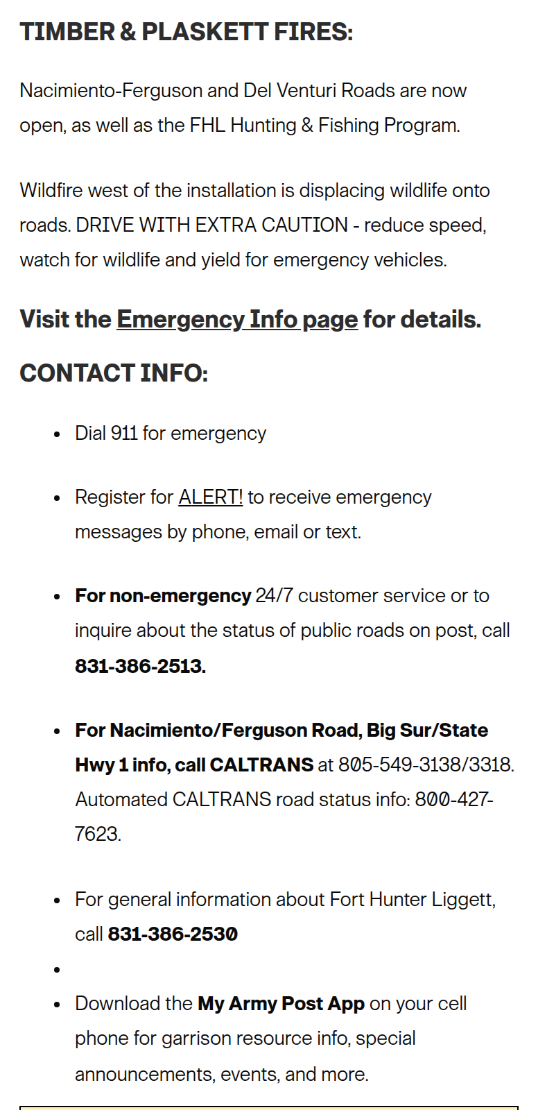
- Published by
- U.S. Army Garrison Fort Hunter Liggett
- United States Army, Installation Management Command. The garrison that holds the eastern descent of this road and its gates.
- Taken from
- https://home.army.mil/liggett/
- Page title
- “Home :: U.S. Army Fort Hunter Liggett”, as it read at the time
- Where on it
- The 'Alerts & Emergencies' block on the garrison's front page.
- Photographed
- 1 October 2026 at 14:01 UTC by placenameguide.com, unretouched and uncropped within the block
- Unchanged since
- 19 September 2026 at 02:03 UTC
Hand-typed and carries no date of its own. It said CLOSED unchanged from 31 August to at least 13 September, then OPEN. Their 24-hour roads line, 831-386-2513, has given a different answer as recently as 15 September.
Go and check it yourself →Los Padres National Forest
speaks for west-forest · Forest orders and forest roads — the western twelve miles, Forest Road 22S01.
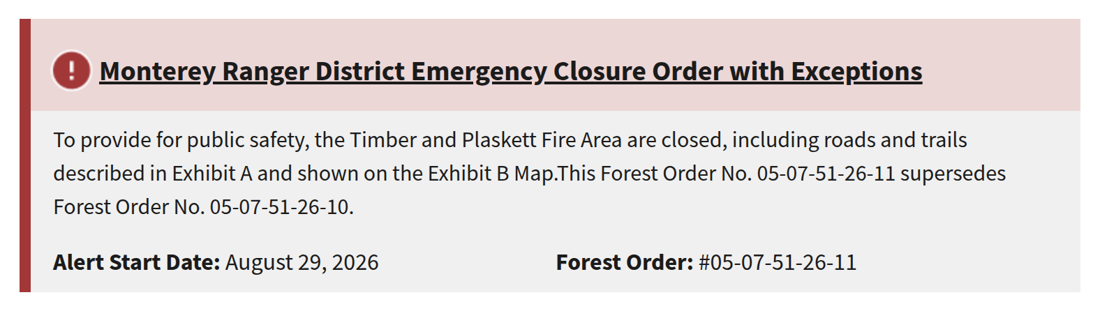
- Published by
- USDA Forest Service — Los Padres National Forest, Monterey Ranger District
- United States Department of Agriculture, Forest Service. The agency that designates this road Forest Road 22S01 and issues the closure orders over it.
- Taken from
- https://www.fs.usda.gov/r05/lospadres/alerts
- Page title
- “Los Padres National Forest | Alerts | Forest Service”, as it read at the time
- Where on it
- The Monterey Ranger District closure order on the forest alerts index.
- Photographed
- 1 October 2026 at 14:01 UTC by placenameguide.com, unretouched and uncropped within the block
- Unchanged since
- 26 September 2026 at 02:03 UTC
Authoritative for its orders and for nothing else. On 28 August 2026 this forest's Current Conditions page still read 'Highway 1 is now open from Cambria to Carmel', four days after Caltrans shut forty miles of it.
Go and check it yourself →Caltrans — SR 1 report
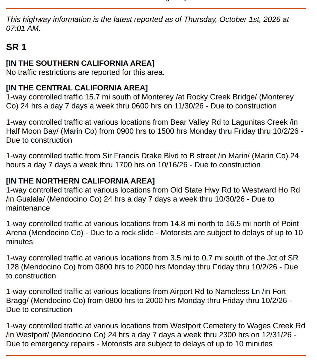
NOT an authority on this road · State highways only. NOT this road.
This page has been rewritten since the previous reading. A person should look at it.
- Published by
- California Department of Transportation (Caltrans), District 5
- State of California. Shown here for what it does NOT contain: Caltrans' remit is the state highway system, and this road is not part of it.
- Taken from
- https://roads.dot.ca.gov/roadscell.php?roadnumber=1
- Page title
- “Road Conditions”, as it read at the time
- Where on it
- Caltrans' own SR 1 conditions report.
- Photographed
- 1 October 2026 at 14:01 UTC by placenameguide.com, unretouched and uncropped within the block
Photographed to show what it does NOT say. Fort Hunter Liggett's own page sends Nacimiento-Fergusson callers here, and Caltrans has never carried this road under any spelling. A reader sent here finds nothing about it, which looks like an answer and is not one.
Go and check it yourself →Monterey County Public Works
speaks for west-forest · County-maintained roads, which is how this one is kept up.
County of Monterey. Maintains this road under contract with the Forest Service and publishes closures on a public ArcGIS feature service.
Read instead, as data, from https://services2.arcgis.com/nOGTdfb4kF4dZljH/arcgis/rest/services/Road_Closures_public/FeatureServer/0, 1 October 2026 at 14:01 UTC.
Their human-readable road-conditions page returns 403 to anything automated, so the data service is the only readable form. Read straight off it twice a day and printed above; the layer's own lastEditDate is shown with it, because a record still standing is not somebody confirming it today.
Go and check it yourself →How to settle it today
- Caltrans District 5 — 805-549-3138 or 805-549-3318
A staffed line. This is the one that answers what the recording cannot. - Fort Hunter Liggett — 831-386-2513
Their own line for the status of public roads on post, which is the eastern half of this road. They also close it at short notice for Army exercises, and that never appears on any website. - Watch Duty and alertmry.org/Map — in a browser
To see whether evacuation zone MRY-F036 covers the road corridor. An order area is lawfully closed to public access, which would shut the road whatever any road notice says.
One thing you will find, that is not true
A Fort Hunter Liggett post saying Nacimiento-Fergusson is closed to all traffic, public and residential, from Highway 1 to the base boundary sixteen miles inland, circulates in search results with no date on it. It is the January 2021 Dolan Fire washout closure, which held until the road reopened on 15 November 2024. Confirmed as the 2021 closure on 28 August 2026. Do not publish it against a current fire.
Why this page prints the disagreement
Bill, 17 September 2026: 'with the N-F page status it will become obvious of incongruence when it exists, and organisations will figure out how to bring it into congruence.' Publishing which body says what, side by side and dated, is not just a hedge for the reader — it is the thing that gets the sources fixed. Nobody at the county can see the Army's banner and nobody at the garrison reads the county's ArcGIS layer. A page that shows both, twice a day, is the only place the two are ever in the same frame.
Print this page (PDF) — the whole of it, with the map, the mileages and every exhibit, for the glovebox where there is no signal.
Our status was last stood behind by a person on 15 September 2026. The agency readings above are taken automatically twice a day and were last taken 1 October 2026 at 14:00 UTC. The operators map · Is Highway 1 open?